Showing posts with label maps. Show all posts

Tuesday, July 11, 2017

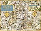
Britain's Tudor Maps County by County


Speed, John. Britain's Tudor Maps County by County. Introduction by Nigel Nicolson. County Commentaries by Alasdair Hawkyard. London: Batsford, published in association with the British Library, 2016.

I love maps! This gorgeously illustrated book of county maps produced by John Speed in the Tudor period provides today's researchers a great tool for understanding our British ancestors who lived then. Each county map is accompanied by a commentary written by Alasair Hawkyard, providing insight into the county's history and the people who resided there. Many maps include offset maps depicting specific places, much as modern-day atlases include maps of larger cities. It's a large over-sized "coffee table" book, but it is so full of useful content for genealogists and historians dealing with the period and place.

Monday, March 28, 2016

Genealogy Saturday at Willard Library in Evansville, Indiana on 16 April 2016

I will be making 4 presentations at Evansville, Indiana's Willard Library on Saturday, 16 April 2016.

Schedule:

9:30-10:30 AM - Social Networking for Genealogists
10:45-11:45 AM - Genealogy in the Clouds
1:00-2:00 PM - Exploring Your Ancestor's World with Maps
2:15-3:15 PM - Check Up Time: Examining Your Old Research

To register for any or all of these, go to http://www.willard.lib.in.us/calendar_of_events/index.php?Type=Genealogy, select the presentation(s) in which you are interested, and sign up!

Hope to see you there.

Thursday, January 27, 2011

I've Been Working on the Railroad . . .

Railroads play an important role in the lives of many of our 19th century ancestors (and even 20th century ancestors). A recently distributed government document details many of the cartographic resources relating to railroads that are available in the National Archives. Entitled Records Relating to Railroads in the Cartographic Section of the National Archives and published as Reference Information Paper 116, the 142 page government document describes each collection for researchers. The 2010 edition was compiled by Peter F. Brauer and can be found in most depository libraries under the SUDOC classification AE 1.124:116. Be sure to check an individual library's catalog as there are some libraries which incorporate government documents in Dewey or LC classification numbers.

Friday, February 12, 2010

A First Time for Everything

Today I was cataloging some recent arrivals for our government documents collection for which we had failed to receive (at least to date) records from Marcive. One of these documents was a map of the Holly Springs and Tombigbee National Forests in Mississippi which is near the area in which I grew up. As I began to look at the map, I noticed that they had labeled U.S. 78 not only U.S. 78 but also Interstate 22. Now, those of us who have travelled that road frequently know that the corridor is the "Future I-22" so I was a bit surprised to already see its new moniker on an official government map.

As I began to think about this, I thought of all the street name changes I've encountered over the years. For example, the 1930 census of Amory, Mississippi includes the street names for the town, but they do not match up with present-day street names. I was eventually able to pinpoint most of the locations by asking my parents. Even they did not remember the old names for the streets, but they were able to tell me the locations of the streets when I told them who lived on the streets. I'm sure that if I'd gone to the trouble of locating an older map of the town that I might have been able to find the names of the streets and then compare to a newer map to identify the present-day locations. After all, there was a "first time" that the new name appeared on a map.

By the way, this particular national forest map would be useful for persons researching areas near the national forests because it shows the sections, townships, and ranges for of not only the forest itself but also the nearby land. The main part of Holly Springs National Forest shows significant portions of Benton, Marshall, Union, Lafayette, and Pontotoc Counties. The Yalobusha Unit for that county shows a large part of Yalobusha County and a small part of Grenada County. For the Tombigbee National Forest, the Trace Unit map shows a large portion of Chickasaw County, some of Pontotoc County, and a couple of sections in Lee County. The Ackerman Unit map shows a significant amount of Winston County and parts of Choctaw and Oktibbeha Counties. The interesting thing is that landmarks such as churches are also identified on the map as well as bodies of water (down to the creek level).
Wednesday, January 09, 2008

Indian Trails Project

Today, I became aware of a "fledgling" map project that looks like a tremendous asset for those of us researching in the Southeast. It's called the Indian Trails Project, and its focus at the moment is primarily on the Cherokee Nation. They have maps dating back to 1748 and maps of the Georgia lotteries and surveys.

Monday, November 26, 2007

FINALLY Published

Arphax has finally released its Family Maps of Monroe County, Mississippi. I've been hounding Greg ever since they first showed up at NGS a few years ago with the first 4 volumes to get Monroe done! I've ordered mine and can't wait for it to arrive! Greg, if you're reading this, I'm still waiting for Itawamba!